Green-GEAR's Challenges

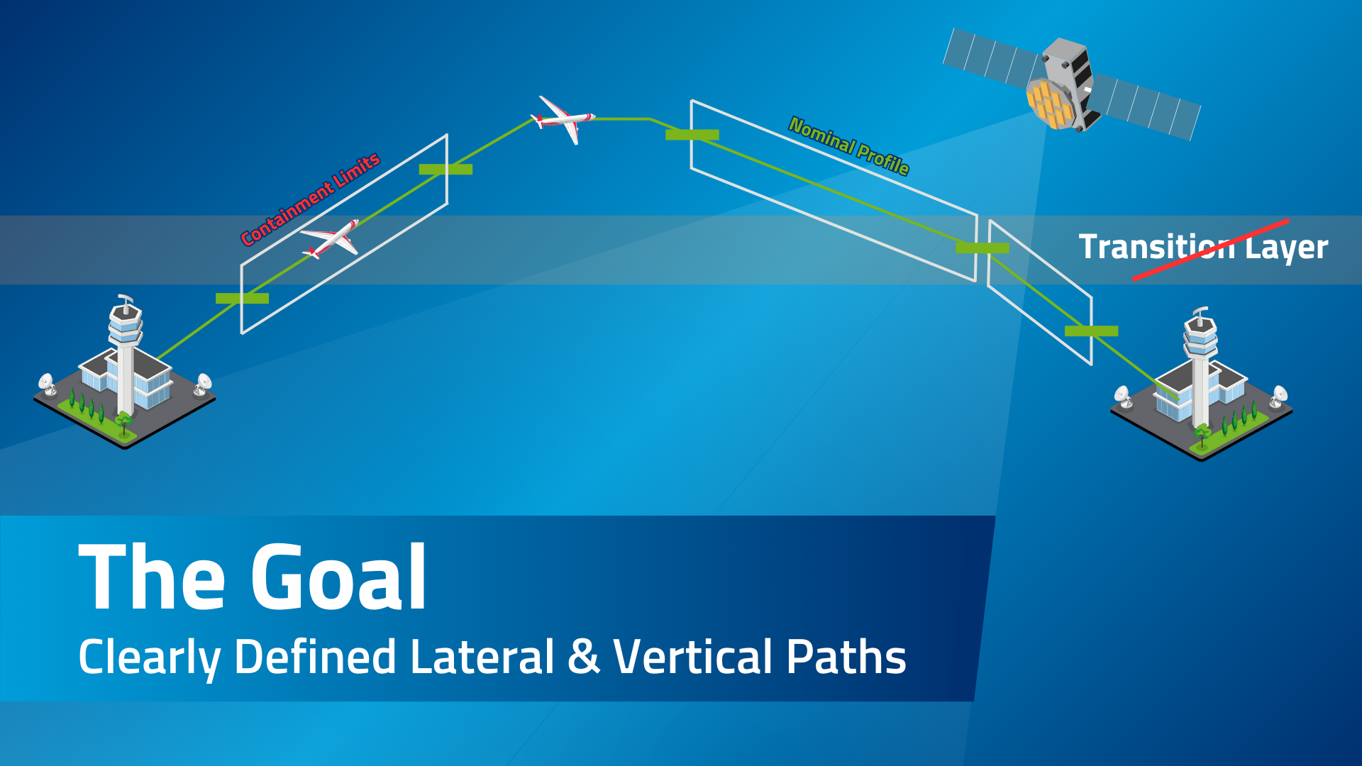
Barometric Altimetry
Aircraft currently navigate their vertical paths based on barometric pressure, which has several inherent limitations. The standard method involves using the ICAO Standard Atmosphere barometric formula, where altitude is calculated based on measured static pressure. This method assumes a fixed pressure at sea level, which leads to potential inaccuracies of several thousand feet.
Different settings are used to manage this during various flight phases...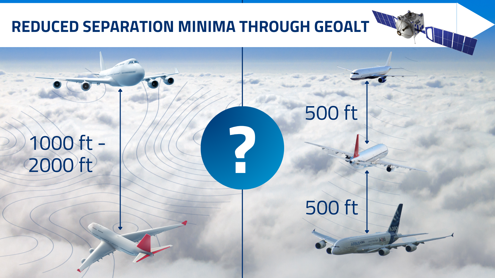
Vertical Separation
The current standard for vertical separation between aircraft, Reduced Vertical Separation Minimum (RVSM), began its process towards network-wide implementation in the late 1990s, marking a significant milestone in air traffic management.
However, rising traffic volumes and the introduction of new aircraft types means that airspace capacity may soon reach its limits (again).
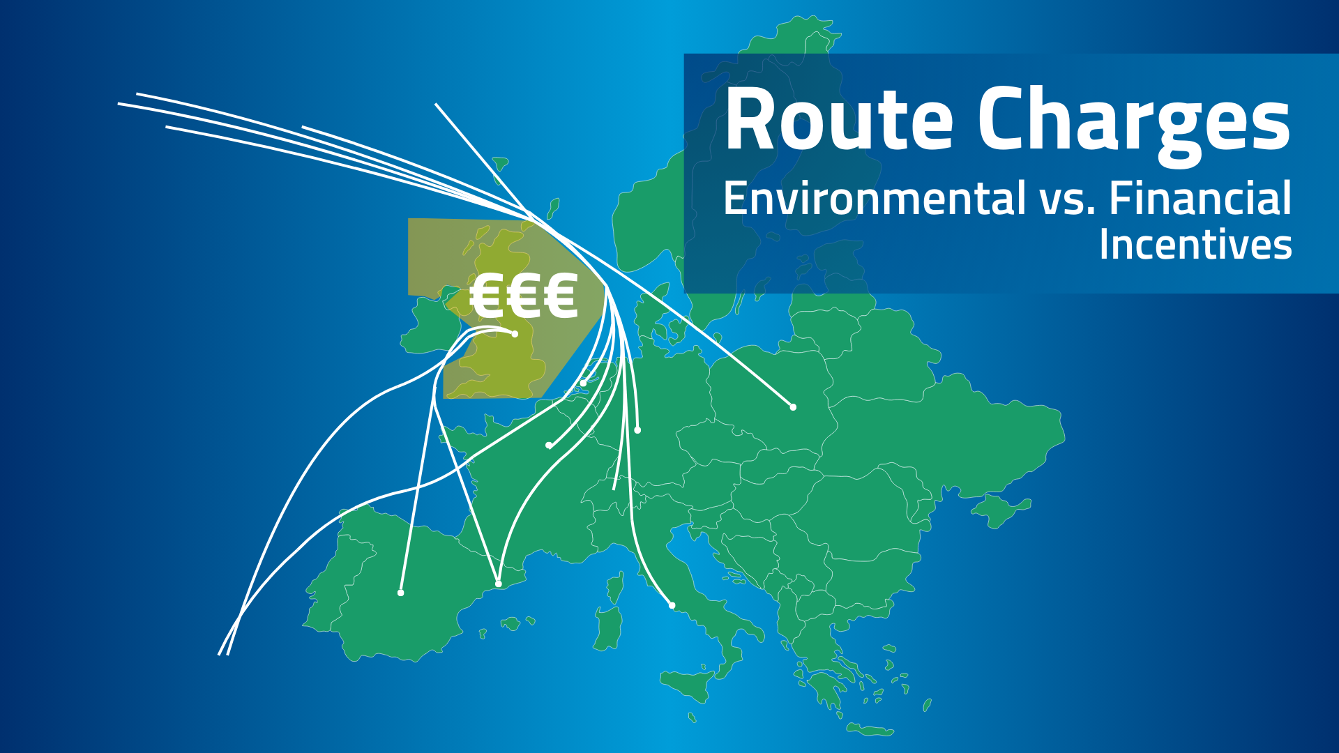
Route Charging
Objectives
The Green-GEAR project embarks on exploratory research to investigate three innovative solutions aimed at potentially transforming aviation towards a more sustainable future:
- Vertical Guidance using Geometric Altimetry (GeoAlt): Our research focuses on the potential of geometric altimetry for developing precise vertical flight paths for aircraft, initially in the Terminal Manoeuvring Area (TMA). This approach aims to optimise climb and descent procedures, potentially reducing fuel inefficiencies where current practices may be constrained.
- Separation Minima (SM): By utilising advanced geometric altimetry, we aim to explore the safe reduction of distances between aircraft during various flight phases. This initiative could enhance airspace capacity and potentially lower CO2 emissions, benefiting both existing aircraft and emerging technologies such as Unmanned Aircraft Systems (UAS) and High-Altitude Operations (HAO) aircraft.
- Green Route Charging (Green RC): We are researching innovative charging mechanisms to encourage airlines to adopt environmentally friendly flight routes. These mechanisms, applied to en-route charges, seek to align costs with environmental impacts, fostering a balance between ecological responsibility and operational efficiency.
The Green-GEAR project represents an exploratory endeavour, pushing the boundaries of technology and operational methods in aviation. Our aim is to explore new possibilities rather than guarantee specific outcomes, as we work towards a greener and more efficient future in air travel.
Approach
-
Approach to GeoAlt
The GeoAlt project addresses several challenges with the current use of barometric altimetry:
1. Transition Layer Variability:
Transition layers exist at different heights worldwide, creating inconsistencies in flight operations.
2. Manual Input Errors:
Switching between standard and QNH altitudes requires manual input, which can introduce errors.
3. Inefficiency and Buffer Requirements:
Due to uncertainties around the transition layer, air traffic control (ATC) needs to build in substantial buffers, leading to inefficiencies.
4. Lost Flight Levels:
The existing transition layer inhibits continuous climbs and descents.
5. Environmental and Capacity Impact:
Uncertainty in vertical aircraft positions limits ATC's ability to design optimal route structures, negatively impacting the environment and airspace capacity
Research Approaches and Methodologies
1. Concept Development:
NATS: Building large fast-time simulations to model airspace design using GeoAlt and comparing it to the current barometric model.
DLR: Conducting aircraft simulations for cruise and descent phases to evaluate performance.
2. Aircraft Performance Analysis:
DLR Expertise: Analyzing individual aircraft performance and proposing the comparison of real flight data (using barometric altimetry) with simulated flight data (using GeoAlt). This involves re-simulating real flights under identical conditions but with GeoAlt.
Validation: Re-simulations will validate models against real flights, enabling the creation of a simpler fast-time simulation model to examine the cumulative effects on fuel consumption and overall efficiency over time.
3. Efficiency and Safety:
- Investigating the net fuel efficiency benefits of a fully geometric network.
- Assessing the removal of the transition layer and its impact on continuous climbs and descents.
- Evaluating the use of GeoAlt for Required Navigation Performance (RNP) arrivals to improve approach efficiency -
Approach to Separation Minima
1. Collision Risk Analysis:NLR: Examining the potential consequences of reducing vertical separation minima to 500 feet, focusing on collision risk in en-route airspace (FL 290-600). The analysis includes establishing accuracy and integrity requirements, assuming a fully GeoAlt system without mixed airspace.
2. Wake Vortex Encounter Risk:
DLR: Focusing on the impact of reduced separation on wake turbulence. This involves detailed simulation and modeling to understand how decreased vertical separation affects the safety and efficiency of air traffic.
3. Safety and Surveillance:
Discussing the need for secondary surveillance radar and the impact of GeoAlt on ATC procedures and aircraft operations.
Considering the effects of jamming and spoofing on the GNSS systems used for GeoAlt, though this is outside the immediate project scope.These approaches collectively aim to validate the feasibility and benefits of transitioning to geometric altimetry and reducing separation minima, thereby improving airspace efficiency and safety.
-
Approach to Green RC
Green Route Charging (GRC)
Research Approach:
Exploratory Research: Initial feasibility studies to assess the viability of GRC solutions before considering their implementation.
Environmental Focus: Emphasis on reducing aviation's climate impact, including CO2 and non-CO2 emissions (e.g., contrails, NOx).Methods:
Modulation of Route Charges (MRC)
Algorithmic Climate Change Functions (aCCFs): Use of aCCFs to identify climate hot spots based on weather forecasts, aiming to avoid areas with high climate impact.
Route Charging Mechanism Development: Investigating charging mechanisms that incentivise routes minimising climate impact, potentially offering credits or imposing premiums based on environmental impact.
Scenario Analysis: Evaluating different scenarios, such as rewarding the avoidance of climate hot spots and the implications of charging mechanisms on ANSPs and airspace users.
Research Approach:
Operational Feasibility: Assessing the practical implementation of charge modulation within the current regulatory framework.
Congestion and Emissions Reduction: Focused on reducing total emissions and traffic congestion through modulated charges.
Methods:
Traffic Data Analysis: Utilising EUROCONTROL DDR2 data from different traffic periods (e.g., February and September 2019) to develop modulation factors. Revenue Workload Ratio Preservation: Ensuring revenue neutrality for ANSPs by proportionally adjusting revenues based on route distance.
Decision Variables: Modulation of route charges (factor M) and temporal displacement of flights to optimise route efficiency.Origin-Destination Charging combined with MRC (ODC + MRC)
Research Approach:
Integrated Charging Model: Combining ODC and MRC to create a comprehensive charging mechanism that addresses both cost efficiency and environmental impact.
Congestion Management: Introducing modulation factors on congested routes to manage sector capacity and optimise route charges.
Methods:
Great Circle Distance Charges: Implementing charges based on the shortest distance between origin and destination, irrespective of the actual route flown.
Redistribution of Charges: Distributing collected charges to overflown ANSPs based on the portion of the route flown within their airspace.
Scenario Constraints: Ensuring flights adhere to minimum cost routes while maintaining sector and airport capacity, and preserving the revenue/workload ratio for ANSPs.
These research approaches and methods are designed to explore and potentially implement solutions that can effectively reduce aviation's environmental impact while maintaining operational feasibility and economic efficiency.